


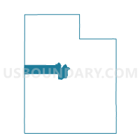
Mona Voting District, Juab County, Utah
About
Outline

Summary
| Unique Area Identifier | 678900 |
| Name | Mona Voting District |
| County | Juab County |
| State | Utah |
| Area (square miles) | 77.76 |
| Land Area (square miles) | 75.37 |
| Water Area (square miles) | 2.39 |
| % of Land Area | 96.93 |
| % of Water Area | 3.07 |
| Latitude of the Internal Point | 39.83552750 |
| Longtitude of the Internal Point | -111.84367060 |
Maps


Graphs
Select a template below for downloading or customizing gragh for Mona Voting District, Juab County, Utah


Neighbors
Neighoring Voting District (by Name) Neighboring Voting District on the Map
- Elberta Unincorporated Voting District, Utah County, UT
- Nephi 3 Voting District, Juab County, UT
- Nephi 4 Voting District, Juab County, UT
- Rocky Ridge Voting District, Juab County, UT
- Santaquin 2 Voting District, Utah County, UT
Top 10 Neighboring County Subdivision (by Population) Neighboring County Subdivision on the Map
- Spanish Fork-Payson CCD, Utah County, UT (73,527)
- Nephi CCD, Juab County, UT (9,366)
- Goshen CCD, Utah County, UT (3,501)
Top 10 Neighboring Place (by Population) Neighboring Place on the Map
Top 10 Neighboring Unified School District (by Population) Neighboring Unified School District on the Map
Top 10 Neighboring State Legislative District Lower Chamber (by Population) Neighboring State Legislative District Lower Chamber on the Map
Top 10 Neighboring State Legislative District Upper Chamber (by Population) Neighboring State Legislative District Upper Chamber on the Map
Top 10 Neighboring 111th Congressional District (by Population) Neighboring 111th Congressional District on the Map
Top 10 Neighboring Census Tract (by Population) Neighboring Census Tract on the Map
- Census Tract 102, Juab County, UT (4,681)
- Census Tract 104.11, Utah County, UT (4,454)
- Census Tract 106, Utah County, UT (3,510)
- Census Tract 104.09, Utah County, UT (2,677)
- Census Tract 105.06, Utah County, UT (1,829)
Top 10 Neighboring 5-Digit ZIP Code Tabulation Area (by Population) Neighboring 5-Digit ZIP Code Tabulation Area on the Map
- 84651, UT (23,457)
- 84655, UT (10,547)
- 84648, UT (5,776)
- 84645, UT (2,620)
- 84633, UT (1,048)
- 84626, UT (410)